
Effective protection of the Earth’s natural environment requires appropriate preventive and remedial measures. In order to accomplish the task, we need, first of all, adequate information, including the presence, spatial distribution and concentration of elements and chemical compounds, especially toxic ones. Such information is provided by research programs, conducted by the Polish Geological Institute since the mid-1980s. Systematic geochemical research is aimed at identifying the chemistry and degree of pollution of rocks, soils, bottom sediments of rivers, streams and lakes, as well as surface and ground waters. More than 170,000 samples have been subjected to chemical analyses. The projects completed so far resulted in the development of a database and a series of geochemical atlases at different scales, as well as in the publication of numerous articles and scientific reports. The National Fund for Environmental Protection and Water Management financed all works, which were commissioned by the Ministry of Environment (currently the Ministry of Climate and Environment).

Water sampling
To illustrate the current condition of the environment, we use the method of geochemical mapping, which synthetically presents the status of the abiotic environment of the hydrosphere and of the lithospheric surface, enabling to measure the geochemical background value and to determine the level and causes of its possible pollution.
According to the intended purpose, the maps are constructed at different scales (overview, regional or detailed). Geochemical maps of a given area are compiled into geochemical atlases, containing not only maps but also extensive commentary texts that present the research methodology and conclusions drawn from the results of the analyses, which allows for a reliable assessment of the degree of pollution of Poland, urban-industrial regions, and protected areas.

Sediment sampling
The knowledge of spatial distribution of chemical elements in a given environment is extremely important not only in searching for and identifying mineral deposits, but also for the purposes of agriculture, forestry, spatial planning, and environmental protection (including the health of people and animals living in the area). Therefore, geochemical maps that show spatial distributions of individual elements, total pollution levels, or the degree of contamination according to various categories (guidelines and regulations) are increasingly used.
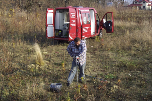
Soil sampling
They are indispensable for making decisions regarding detailed studying, monitoring and remediation of individual elements of the natural environment, as well as in analysing the relationships between environmental factors and human health. As the ecological awareness of the society increases, the state administration units of various levels, ecological agencies, scientific institutes, and universities more and more often use the information provided by the geochemical studies of the Polish Geological Institute.
Geochemical samples archives
Geochemical mapping research is expensive. Therefore, in the first stage of research projects, overview maps are prepared, which allow for a quick and relatively inexpensive assessment of environmental pollution over large areas (e.g. for the entire country), and for the identification of highly polluted areas of a regional or local nature. At that stage of research, it is often possible to identify the likely pollution sources. Their impact on the environment is controlled on a continuous basis by systematic monitoring of river and stream sediments, which make it particularly easy and quick to record the introduction of pollutants into the aquatic environment.
Sample storage facility in the field
In the second stage of research, maps are prepared to show the pollution level on regional scales in preselected areas, and, finally, detailed studies are carried out in the regions. Such a workflow greatly reduces both the time and cost of the research. Most often, the surface area of the region qualified for detailed research accounts for a small percentage of the area studied in the first stage. In 1990, based on the above assumptions, the Polish Geological Institute started the Poland’s first multi-year 3-stage geochemical mapping project that focused on the problems of natural environment.
Stage I (1990–1995)
During the first stage of research, the Geochemical Atlas of Poland was developed (scale 1: 500,000; printed at a scale of 1: 2,500,000), which covered studies of the topsoil layer, bottom sediments of rivers, streams and stagnant water bodies, as well as surface waters throughout the country.
In addition to defining the geochemical background level, the study also indicated areas of regional or local anomalies. Apart from natural anomalies associated with various lithologies and chemical compositions of the geological substrate across the country, anthropogenic anomalies have also been noted in the areas of historical extraction of metal ores and long-time industrial and municipal activity, as well as in places where toxic chemicals are stored, and around illegal landfills and sewage discharges.
Natural variability in the contents of many elements (Ba, Co, Cr, Cu, Fe, Mg, Ni, V and Y) in soils and sediments allowed for the identification of two distinct geochemical provinces of Poland: the southern one, including the Carpathians, Lower Silesia, Upper Silesia and small areas of the Lublin Upland, and the northern one, covering the rest of the country. The soils and alluvial sediments of the southern province in areas of pre-Quaternary bedrock contain greater concentrations of many elements compared to the northern province. Their lower contents in the northern province is due to the occurrence of Pleistocene glacial deposits, which are mainly sandy and heavily leached.
Disturbingly high contents of many compounds and elements have been detected in surface waters of Poland: phosphates, chlorides, sulphates, barium, manganese, potassium, sodium and zinc. In the last few years, the chemical condition of surface waters has improved significantly as a result of the abandonment of production by industrial plants,
implementation of modern technologies, and the construction of new municipal and industrial wastewater treatment plants.
Contrary to popular belief, Poland is not a catastrophically polluted country. However, the survey geochemical research showed that the permissible levels of harmful substances were exceeded in soils, waters and sediments in some regions of the country. The research generally showed a low level of metal pollution (embracing approx. 1% of the country’s area). Although increased cadmium, lead, zinc and copper contents were recorded in the topsoil of large cities of Poland in relation to the geochemical background level, it should be emphasized that they are much lower than in agglomerations of many other European countries. Accumulation of many elements that are toxic to living organisms takes place in highly industrialised areas, especially in those of mining and processing of metal ores (in Lower and Upper Silesia), as well as in urban areas.
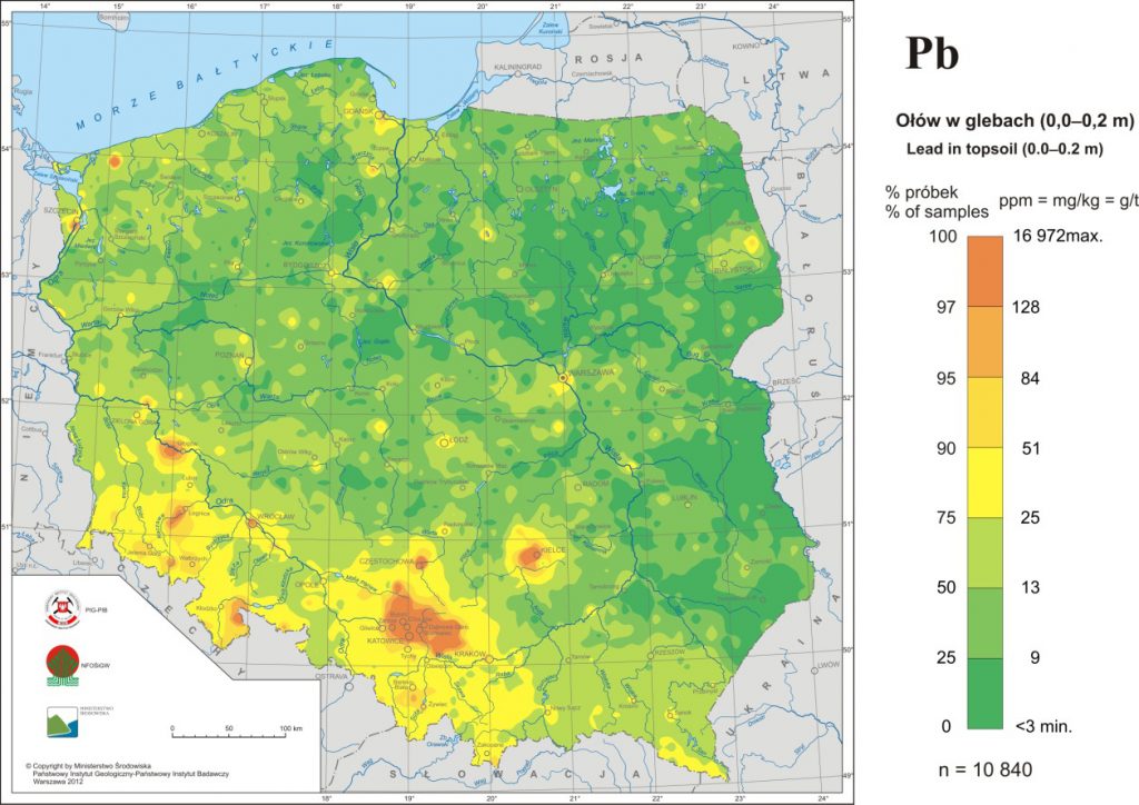
One of such elements is lead, the content of which in the soils of Poland is presented in the map below.
Szczegółowa mapa geochemiczna Górnego Śląska 1:25 000
The lead content varies slightly in the soils across the Polish Lowlands. In eastern Poland, it is often below 13 mg/kg, whereas in the western part, it ranges from 9 to 25 mg/kg. In the soils of the Carpathians and Sudetes, the lead content is above 13 mg/kg, ranging to 50 mg/kg in some areas. In most of the soils of Upper Silesia, the lead content is higher than 50 mg/kg, which is due to both the presence of Triassic Zn-Pb ore-bearing dolomites on the surface or under a thin overburden and the anthropogenic enrichment of topsoil with lead originating from mining and processing of zinc-lead ores.
Stage II (1991–2005)
As part of this stage, geochemical atlases were produced at regional scales (from 1:50,000 to 1: 200,000) for the major urban and industrial areas. The research was limited to the areas of detected anomalies, which cover a small percentage of the territory of Poland. Geochemical atlases of the Upper Silesia agglomeration, Warsaw, Kraków, Kielce, Łódź, Poznań, Szczecin, Wałbrzych, Wrocław, Gdańsk Coast, Częstochowa and Legnica-Głogów Copper District were developed.
Among the earliest regional studies was the one covering the area of Upper Silesia, which is a unique region in terms of the geochemical picture of Poland, being a distinct regional anomaly of the assemblage of Pb, Zn and Cd elements. This area is the most densely populated and industrialised region of Poland. In the north and east of this region, Carboniferous deposits are covered with Triassic carbonates containing zinc and lead ores. The results of research on selected elements allowed for the determination of the specific geochemical background level of the region, controlled by natural factors, and the identification of anthropogenically polluted areas. They are associated primarily with two industrial complexes: historical mining, processing and metallurgy of zinc-lead ores, as well as hard coal mining and the energy industry.
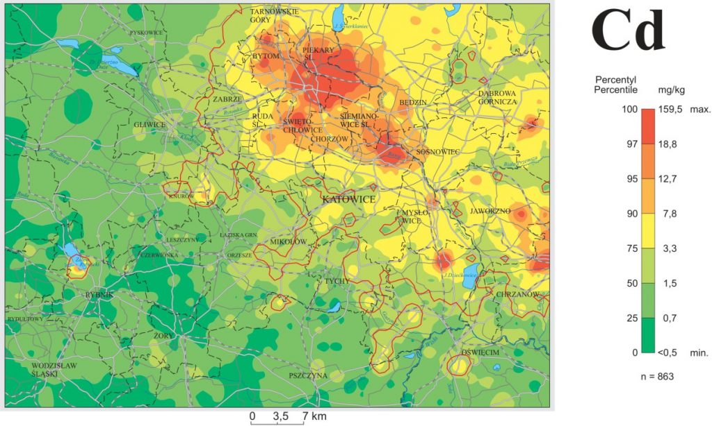
Cadmium concentration in topsoil (0.0–0.2m) of the Upper Silesia Agglomeration
A high content of cadmium (of lead and zinc as well) was recorded in the area of massive anomaly covering the municipal districts of Bytom, Piekary Śląskie, Świętochłowice, Chorzów and Siemianowice Śląskie, northern parts of the Katowice and Ruda Śląska districts, and the western part of the Sosnowiec district. In the anomaly area, the topsoil layer contains more than 250 mg/kg of lead, 780 mg/kg of zinc, and 10 mg/kg of cadmium. In the towns located in the western and southern parts of the agglomeration, the contents of harmful elements remain within the limits of natural geochemical background level.
The towns that have the most cadmium-polluted soils include Piekary Śląskie and Bytom. The maximum concentrations are found in the soils of the Brynica valley in the Brzozowice residential area of Piekary Śląskie. They contain up to 160 mg/kg of cadmium. In Świętochłowice, the maximum cadmium concentration is 41 mg/kg, and a slightly lower level is reported from Chorzów – 27 mg/kg.
Stage III (1996–2029)
Detailed geochemical maps at the scale of 1: 25,000 are planned to be compiled for the country’s most polluted regions (approx. 1.5% of the territory of Poland):
— the Silesian-Cracow area of the Pb-Cd-Zn anomaly (approx. 2,400 km²),
— areas affected by the Głogów and Legnica copper smelters (approx. 1,200 km²),
— some regions of the historical mining and metallurgy in Lower Silesia (approx. 500 km²).
This stage of geochemical research was initiated in the Silesian-Cracow region. Detailed geochemical mapping, aimed at identifying and assessing the chemical degradation of this area, started in 1996 by the development of a pilot sheet of Detailed Geochemical Map of Upper Silesia (SMGGŚ) 1: 25,000 – Sławków sheet. The project of systematic mapping is underway and its completion is expected in 2029. The progress of the work is presented in the index below.
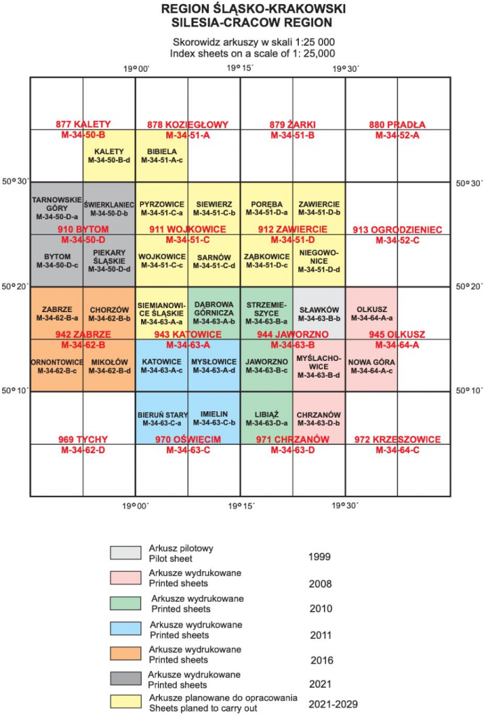
Silesia – Cracow Region
The final effect of each 1: 25,000 scale sheet is the atlas containing single-element geochemical maps and an explanatory text (in printed and digital versions).
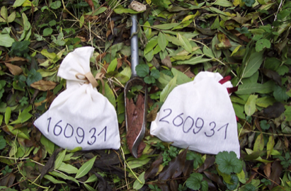
Samples collected from topsoil and subsoil
The research covers analyses of soils from two depth ranges: 0.0−0.3 m (topsoil) and 0.8−1.0 m (subsoil), as well as of sediments and waters from rivers, streams, ditches, canals and stagnant water bodies. The soils are sampled at a density of 16 samples/km². The distance between the sampling points on the watercourses is 250 m. The contents of Ag, Al, As, Ba, Ca, Cd, Co, Cr, Cu, Fe, Hg, Mg, Mn, Ni, P, Pb, S, Sr, Ti, V and Zn in the soils and sediments are determined after dissolving the samples in aqua regia. Soil’s pH, organic carbon content, and grain-size composition are also determined. The water analyses include determinations of Ag, Al, As, B, Ba, Ca, Cd, Cl, Co, Cu, Fe, K, Li, Mg, Mn, Mo, Na, Ni, P, Pb, Sb, SiO2 , SO4, Sr, Ti, Tl, U, Zn, pH and EC. The results of research carried out so far allowed identifying areas where the soils, sediments and waters were heavily polluted.
In the areas of the individual 1: 25,000 scale sheets, the major sources of metals, sulfur and arsenic are the remains of dumps from the mining and flotation of Zn-Pb ores, dumps of historical waste from zinc smelters (being the source of zinc, cadmium, arsenic, lead and sulfur concentrations in soils), modern iron and steel metallurgy (enabling the dispersion of
chromium, manganese, molybdenum, copper and tin), and combustion of coal, which is accompanied by emissions of mercury, sulfur, and metals-containing dust. Surface waters in the areas of Zn- Pb ore extraction show increased electrolytic conductivity levels and neutral pH, and contain heavy metals and Na, Cl, K, Li, B, Ba, Sr and SO4 – components that come mainly from mine water discharges.
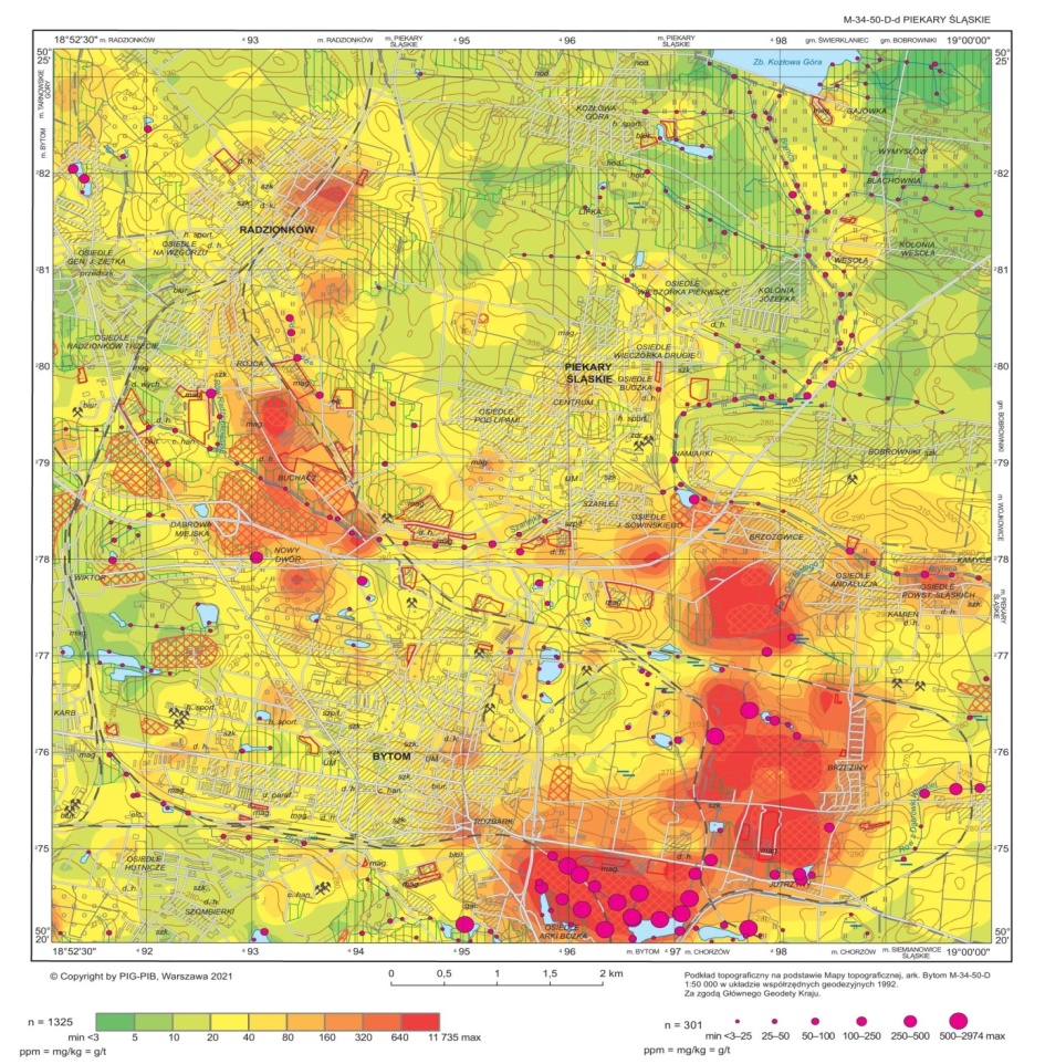
Arsenic concentration in topsoil (0.0–0.3 m) and sediments in the Piekary Śląskie map sheet
Areas of intense anomalies of arsenic, lead, cadmium and zinc in soils have been found in many regions. An example is the south-eastern part of the area covered by the Piekary Śląskie sheet, where the arsenic content in the topsoil layer exceeds 160 mg/kg. In soils extremely polluted with arsenic, the concentrations attain a level of 1,500–5,000 mg/kg in the Żabie Doły area, and up to 1,395 mg/kg in the Buchacz-Nowy Dwór region.
Sediments of numerous water bodies at the southern boundary of the map sheet are heavily polluted with arsenic and metals. Sediments of small reservoirs in the area of Mickiewicz Park in Bytom contain up to 8 mg/kg of silver, 760 mg/kg of arsenic, 126 mg/kg of cadmium, 471 mg/kg of chromium, 37.61% of iron, 162 mg/kg of nickel, and 2,810 mg/kg of lead and 29,590 mg/kg of zinc. The probable source of these elements is the drainage of old waste dumps from Zn-Pb ore mining and iron smelting. In this region, the Graniczny Potok stream, which transports sediments from the reservoirs of the Żabie Doły Nature and Landscape Complex, where waste from zinc and lead ore flotation was stored, flows into the Bytomka River.
Anna Pasieczna